
Preferences: projection, GPS source, stylus and capture accuracy
Full reference of Field Manager settings: projection system, GPS source, minimum capture accuracy, stylus support and absolute snap.
Preferences: projection, GPS source, stylus and capture accuracy
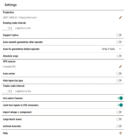
Preferences window
Projection:
Allows selecting the map projection of the current activity. Tapping the edit icon opens a window where you can search for any of the Proj4-format projections available in the project, either by its SRID, description, or definition.
This selector is organized as a resource manager, with the same look as the Resource Manager: SRID, Name, and Proj4 columns -all sortable by tapping their header- and a search box that filters among thousands of projections without delay, because searching and sorting are resolved in the database.
The coordinate system of the active map is pinned at the top of the list -for example “Map system · 4326”-, so it can be chosen with a single tap without having to search for it among all the available projections.
From the same selector you can create, edit, or delete your own projections. The new button opens a dialog that asks for Name, the Proj4 definition (mandatory; before saving it is validated by building the transformation to WGS84, thus avoiding saving an invalid definition) and, optionally, the WKT/srtext (descriptive only). To edit or delete an existing projection, use its row menu (Edit/Delete); when editing, the SRID is fixed (it cannot be modified). You cannot edit or delete the projection currently selected for the map or for any project resource.
Drawing node interval:
Defines the distance between nodes when drawing freehand on the map. The unit depends on the projection used. This option only applies to the current activity's map.
Support stylus:
General option, only effective on devices whose screen recognizes the pen as a pen rather than a finger: the pen supplied with the device or the official model for it, such as S Pen. A generic pen bought separately does not enable this feature, even if it has a fine tip. It lets you distinguish between the pen's touch for drawing during geometry editing and fingers for panning and zooming. The pan button on the map will only be visible while this option is disabled.
With this option enabled, the stylus's side button adds its own gestures, which vary by context:
- Editing a geometry: a click of the button toggles between the erase tool and the last drawing tool used. Holding the button down while dragging the pen pans the map, without drawing.
- Navigating (not editing): holding the button down toggles the measure tool.
- Outside the exploration context: the button works as the Back key.
Auto-Smooth Geometries After Operation:
Applies an edge smoothing (see Geometry Editor) after performing operations between two geometries (difference, intersection, union, etc.). When enabling it, the minimum and maximum acceptable values will be requested. Option valid for the current activity.
Auto-Repair Geometries Before Operation:
Checks and repairs geometries before running an operation between two of them during editing. This prevents unexpected results in malformed geometries. It can be set to run always, only when the operation fails, or be completely disabled. Applies to the current activity.
Absolute snap:
(see Snap in Geometry Editor). Option applicable to the current activity.
GPS source:
When editing this option, a window opens to select the GPS to use in the activity. You can choose between the built-in positioning hardware or any Bluetooth device previously paired (with Bluetooth enabled). To connect an external device, it must transmit coordinates using the NMEA protocol. Option valid at the project level.
Every paired unit shows up twice in that list: under its own name, and as " + RTK (NTRIP)", which is the same receiver but fed with differential corrections (see the next section). At the end of the list sits "Set up RTK corrections (NTRIP)…", which opens the caster form.
RTK corrections (NTRIP):
Field Manager can pull differential corrections from an NTRIP caster over the Internet and forward them to the receiver through the same Bluetooth link, so you can work at centimetre accuracy without depending on the manufacturer's own software. It works with any receiver that accepts incoming corrections (u-blox F9P, Topcon or Leica, for instance): the application does not interpret the corrections, it just hands them to the receiver, and it is the receiver that computes the corrected position. A unit that only streams NMEA and takes no corrections simply ignores them and keeps delivering an autonomous position.
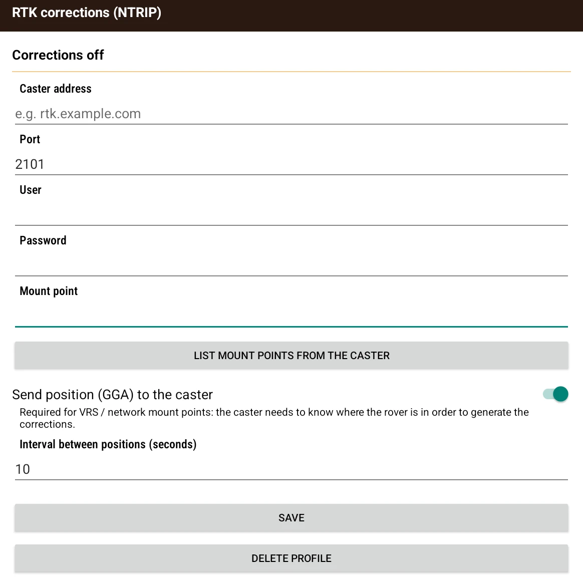
The "Set up RTK corrections (NTRIP)…" entry in GPS source opens the form:
- Caster address and Port (2101 by default, the usual NTRIP port).
- User and Password for the correction service.
- Mount point: the specific correction stream inside the caster. You can type it, but it is better to use the List mount points from the caster button, which only needs the address to be filled in: it queries the caster and offers whatever it publishes in a list, so you do not have to type a name that is also case sensitive. If the caster returns none, or cannot be reached, a message says so.
- Send position (GGA) to the caster, with its Interval between positions (seconds) (10 by default). It is required for VRS or network mount points, where the caster needs to know where the rover is in order to generate the corrections. If the mount point was picked from the list and declares that it needs it, the option is switched on automatically.
- Save and Delete profile. Nothing is saved without a caster address and a mount point.
Credentials are stored encrypted in the device's secure store, not in the project: they do not travel in the project zip and are not shared when transferring data. If the device cannot store them securely, the application says so and does not save them rather than leaving them in the clear.
At the top of the screen, above the fields, a line reports the state of the correction: Corrections off, Connecting to the caster…, Corrections received (with how many seconds ago the last one arrived and how many kB were pulled) or No corrections — retrying. With a correction locked in, the quality indicator in the map status bar switches to RTK (fixed solution) or FRTK (float), next to the coordinates and the accuracy.
⚠️ If the Internet connection drops or the caster stops answering, you do not lose the position: the receiver keeps delivering autonomous fixes and the activity uses them just the same, with that status line reporting the retries.
Minimal capture precision required:
Only available for core logging activities. It lets you set the minimum precision the GPS must reach before creating a geopositioned tuple (see Core Logging).
Keep GPS on during core logging:
Also exclusive to core logging. Keeps the GPS on continuously to maintain precision. If disabled, the GPS will only turn on when recording a point, which may slow the process but saves battery.
Geocoder in main panel:
Only for core logging. When enabled, the geocoder opens inside the main panel of the logging screen and the data grid moves to the secondary panel: the screen is split so you can see the table while entering a record. By default, the geocoder opens full screen and covers the grid. While the embedded geocoder is active, the sampling and action buttons in the side panel are hidden.
Open in Data Browser on select:
Sets what the app does when you select a tuple, with separate settings for the map and core logging. The three options are Don't open; Scroll into view if hidden, which scrolls the data browser to the selected row without changing tables (and only acts if that browser already shows the layer); and Open in Data Browser, which opens that tuple directly in the data browser. See Strip Log and Selecting on the map.
Auto center:
Centers the map on the GPS position when the cursor approaches the edges or falls outside the limits.
Tracks node interval:
Defines the distance between nodes when capturing tracks (see Tracks). The unit depends on the projection used. It only applies to the current activity's map.
Hide layers by type:
This option affects “Hide the rest” in the user layers menu, or holding down the  button on a layer. If enabled, only layers of the same type (raster or table) will be hidden. (See Layer menu).
Use native Camera:
When enabled, photos will be taken with the device's native application. Otherwise, the camera provided by the app will be used, which may differ in features or image quality.
Limit text inputs to 254 characters:
Restricts the text fields of the geocoding assistant to 254 characters, making them compatible with some limited export formats.
Import always z component:
When importing a table with 2D coordinates, the Z component is added with a value of 0.0.
Large touch areas:
Some interface elements are enlarged to make them easier to use.
Activate tutorials:
Reactivates the project's tutorials that have been disabled.
AI Integration…:
Opens the Gemini API key settings, which enable automatic transcription of audio recorded in layers. The dialog has a field for the key, a show/hide button, a Get API key at Google AI Studio link and a Test button that checks with the server that the key is valid before saving it. Without a valid key, the transcription options do not appear (see AI audio transcription).
Hardware calibrator:
Opens a device diagnostic screen with two sections. Compass / IMU shows the current accuracy of the accelerometer and magnetometer, magnetic field strength in µT, a warning about possible magnetic interference (nearby metal, magnets or electronics), and the Calibrate the compass guide, which asks you to move the device through the air in a figure eight until magnetometer accuracy reaches High. Device sensors lists the accelerometer, magnetometer, gyroscope, gravity sensor and rotation vector. If compass sensors are missing, the screen says so: that device cannot measure the orientation of a geological structure.
You've read enough. Try it with your own project.
20 days free, with your data. If you get stuck: the manual — and us.
Secure payment with Stripe · Cancel anytime.